iMahal Interview Series:
David Gimbel
July 22, 2001
iMahal:
We initially heard about Archaeos from media reports on the Vijayanagara project. Part of the reason for the media covering Archaeos was the use of modern technology in archeology field work. Please tell us more about it. You use computers a lot. We assume that computers provide efficiency. How much better is the information?
 Gimbel:
I think you have to split that up into two sections. The first thing is that you couldn't do this type of work without computers. On most days we shoot (meaning to measure and store data) between 500 and 1000 points. My record is about 1000. I was talking to somebody yesterday who wrote the surveying software that we use. When I told him I shot between 500 and 1000 points a day, the guy was really surprised. I said, "Well, I'm not a professionally trained land surveyor. Is that unusual?" The guy said, "yes, that's really unusual to shoot that many points in a day." So I think that the ability to gather that much information and to be able to effectively model it wouldn't be possible without computers. You would have a very different type of study.
Gimbel:
I think you have to split that up into two sections. The first thing is that you couldn't do this type of work without computers. On most days we shoot (meaning to measure and store data) between 500 and 1000 points. My record is about 1000. I was talking to somebody yesterday who wrote the surveying software that we use. When I told him I shot between 500 and 1000 points a day, the guy was really surprised. I said, "Well, I'm not a professionally trained land surveyor. Is that unusual?" The guy said, "yes, that's really unusual to shoot that many points in a day." So I think that the ability to gather that much information and to be able to effectively model it wouldn't be possible without computers. You would have a very different type of study.
|
|
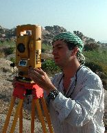
Shooting a Point
|
Let me explain what happens when we shoot a point. We use a surveying device called a Total Station: it sends out an infrared beam through the lens to a prism mounted on a pole. The prism refracts the beam back to the Total Station. The Total Station's on board circuits then calculate and record the point's Northing, Easting, and Elevation, based upon the horizontal distance, vertical distance, and slope between the prism from the machine. This information is then sent through a cable to a small handheld computer that functions as a data collection device. Because the data collector is used to control the Total Station's electronic functions and download data from it we are also able to simultaneously record two types of additional information about each of the survey points. We call these categories of additional information "control codes" and "feature codes."
We use the technology to map large areas, and we are able to do it quickly. Speed gives us new advantages. The North Ridge at Vijayanagara is a largely denuded expanse. It stood between the Royal City and the Sacred City, and upon first sight you might conclude that not much of anything occurred along this ridge. But what we found during the surveying process was that it is almost entirely covered with all sorts of construction and habitation debris. A lot of remains have been taken away over the ages, typically to build the many farmer's walls that now crisscross the landscape.
|
|
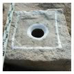
Mortar Block
|
Vijayanagara is built on these weird formations of metamorphic rock and because of this there are many features of human habitation that you can still see along the North Ridge. You can see where people cut into the surface of the rock in order to make wall seatings. You can see pivot points cut into the stone, which functioned as the equivalents of hinges for doors. You can see mortars cut into the bedrock. There are "anchor holes" and "ties," structural elements that originally held walls and other architectural features in place. Both ancient and modern quarry marks also litter the landscape indicating where the rock was broken up as building materials. So, despite the fact that there aren't a lot of walls and structures that are still standing, there are all these diagnostic indicators of the structures that were once there.
When we shoot a survey point we also enter a "control code" into the data collector to describe its geometric category. When shooting a point with somebody I might say, "This is either the first point in a polygon, or a point in a polygon, or a point in an open polygon." These are the "control codes," or commands that will later allow the CAD program to draw shapes properly. But what we also do is record other information about each coordinate point. We can choose one of nearly 160 different "feature codes" to describe each point further. Each feature code contains about five or six nested subcategories, or fields, of information. The surveyor holding the prism might say, for example, "This is a bedrock mortar. It's 60 centimeters across. It has a square surround. It has no contents in it," and that information is entered into the data collector and recorded.
So every point that we shoot has nested categories of information associated with it. That's where this is a departure from the way traditional archeological surveying is usually done. There's no way that you could collect this kind of data on this scale using non-computer-aided technology. It would just be too time consuming. It's theoretically possible; you could have a thousand people out there with pens, notebooks, alidades and theodolites, but it's just not something anyone would ever do.
iMahal:
So what you are doing is, in the field with computers, you are creating a database of facts that go with coordinates?
Gimbel:
Exactly. We try to preserve this data. What we get is a map that shows tens of thousands of geometrical points, each of which has additional data associated with it. On the computer you can click on any single point, and it's going to effectively say, "this is bedrock mortar, these are the dimensions of it, and here are parameters that relate to it." So you can see information affixed to every single point.
|
..Storing the data this way also allows us to think up new ways to process the information..
|
Obviously the raw data is something we store using standard formats. It doesn't matter how you keep it, because you still have the raw data. People can then import that data into other programs, such as Geographical Information Systems (GIS) so that they can query and model it in any way that they want. Storing the data this way also allows us to think up new ways to process the information. Let me give you an example of a query we might invent in the future: "How many mortar blocks exist within 20 meters of the main road?" This sort of question is important, because the answer will provide information about economic activity: mortars are used to process grain. Without the data stored in the computer in a standard format, it would be extremely difficult get answers to such questions.
All photographs copyright and courtesy of David Gimbel or Archaeos